Historické zajímavosti
Po výjezdu serpentinami z Ivančic směrem k Moravskému Krumlovu jsou po levé straně rovinaté pozemky a mnozí z řidičů si nedaleko silnice všimnou betonového soklu komolého tvaru, který z polí vyčnívá. Je to pozůstatek radarové stanice, která zde byla v průběhu války vybudována německou armádou. Druhý sokl je asi 400 metrů východním směrem.
Koncem srpna 1936 byla obecní zastupitelstva v Budkovicích a Němčicích a obyvatelé těchto obcí nemile překvapena dopisem z Ministerstva veřejných prací ze dne 23. srpna 1936. V dopisu byla zastupitelstva informována, že v nejbližší době bude realizována výstavba státního pomocného letiště Ivančice v rozloze asi 48 ha na pozemcích obcí Budkovice a Němčice. Zároveň byla v dopisu výzva, aby majitelé určené plochy již neosívali.
Postižení občané se prostřednictvím obecních zastupitelstev a dalších organizací bránili, ale marné bylo sepisovaní rezolucí a cest do Prahy na Ministerstvo zemědělství a korespondence s různými organizacemi, aby na stavbu letiště byly použity jiné pozemky. Ministerstvo veřejných prací sice dopisem ze dne 13. dubna 1937 uznává, že dosavadní vlastníci těchto pozemků jsou odnětím pozemků poškozeni, ale za daných okolností nemůže od stavby letiště ustoupiti. Zřízení pomocného letiště Ivančice na pozemcích obcí Budkovice a Němčice je v celostátním zájmu naprosto nutné.
Zabráním pozemků potřebných ke zřízení letiště byli postiženi hlavně občané, kterým byly tyto pozemky jediným zdrojem obživy. Dne 21. dubna 1937 provedl Okresní úřad v Moravském Krumlově za přítomnosti úředního znalce úřední odhad nemovitostí, které přicházely v úvahu pro zřízení letiště. Odhad vycházel z obnosu 20 000 Kč za 1 hektar a pro všechny poškozené majitele byla vypočítána výše obnosu podle rozlohy zabavených pozemků. Ještě na podzim 1937 žádali občané z Budkovic o výměně pozemků p. Sojky na letiště. Vyhověno také nebylo.
Se stavbou letiště se začalo na podzim 1937 za vedení inženýrů státní stavební správy v Olomouci. Pozemky byly srovnány a rozorány. Na jaře 1938 byla upravena plocha letiště přípravou k osetí travou a zasetí samého se zúčastnilo 12 rolníků z Budkovic s potahy po dobu 14 dnů. Stará “Vanecká” cesta od severního okraje Budkovic směrem k němčickým “písečňákům” přestala existovat.
V důsledku válečného napětí s hitlerovským Německem byla na letišti vojenská hlídka, která v době před mobilizací v roce 1938 byla zesílena na jednu pomocnou rotu. Několikrát tu přistála vojenská pozorovací i stíhací letadla. Letiště bylo pro svou příznivou polohu považováno za jedno nejlepších pomocných letišť na území státu.
V listopadu 1938 byla uvolněna polní “Vanecká” cesta pro provoz přes letiště, protože Mnichovskou dohodou pozbylo letiště významu a bylo zrušeno. Hranice Třetí říše byly pouze několik set metrů od letiště. V březnu 1939 byla plocha opět rozměřena a pozemky byly vráceny původním majitelům.
Během okupace byla na území Protektorátu vybudována příslušníky leteckého spojovacího vojska síť pozemních radarových stanic letectva. Podle důležitosti a z taktických důvodů byly rozděleny do skupin I. II. a III. Úkolem stanic bylo dodávat spolehlivé informace o leteckém provozu nad sledovaným územím. Kromě radarů byly na stanicích i další budovy s provozním, technickým a hygienickým zařízením.
Taková stanice byla od roku 1940 stavěna na místě dřívějšího letiště, přičemž pozemky byly zabírány pro potřeby německé armády jen částečně. Jednou z prvních akcí bylo zajištění pitné vody z obecní studny u domu č. 31 (Štěpanovský) stavbou vodovodu do budoucí stanice a výstavba dřevěných domků. Ještě v tomto roce přibylo do Budkovic 50 německých žen. Při budování staveb měli obyvatelé Budkovic i Němčic mnoho potíží. Němci, kteří stavbu prováděli, nařizovali obecním úřadům, že místní občané, zvláště rolníci s potahy musí na stavbách pomáhat, hlavně dovážet stavební materiál. To se však nelíbilo zemědělcům, kteří často mívali polní práce, nebo odmítali účast na práci pro Němce. Starostové obcí se však vymlouvat nemohli, protože jim bylo vyhrožováno kriminálem a gestapem, jestliže nezajistí požadovanou pomoc. Jiná je informace, že Němci za tyto práce dobře platili, takže byla možnost výdělku. Stejně tak byla možnost dobrého výdělku za řemeslnické práce při stavbě a zařizování všech objektů.
Stanice spadala pod brněnský obvod, podle důležitosti do I. řádu s krycím názvem Brumbär. Náleželo k ní 28 poplachových hlásek. Dva dosud zachovalé betonové sokly svědčí o instalaci radarů FuMG 65 WURZBURG RIESE a budova (dnes rozvaliny) pro radar Jagdschloss (lovecký zámeček).
Do čtverce byly postaveny čtyři stavby vzdálené od sebe asi 400 metrů, místní občané jim říkali “kolotoče” a mezi nimi ve středu budova s dalším radarem, ve které byly různé přístroje a dynama na výrobu elektrického proudu. Proud byl pak veden do všech čtyřech budov. Pozemky mezi těmito stavbami byly přístupné a byly obdělávány. Jen ojediněle přistálo na pozemcích letadlo typu Storch, t.j. letadlo lehlého provedení, které nevyžaduje kvalitní letiště. V roce 1944 byly stavby před dokončením a začaly se používat. Dne 16. listopadu 1944 přijelo do Budkovic 150 mladých žen, určených k obsluze stanice. Říkalo se jim “Blitzmädchen” podle odznaku na uniformě. Moc si Budkovic neužily, do konce války zbývalo několik měsíců.
K čemu vlastně tato stanice sloužila? Původní záměr byl zajištění kontroly o leteckém provozu nad Protekrorátem. Po vylodění spojenců v Itálii v červenci 1943 a jejich postupu do severní části země, začala část bombardovacích letadel startovat z italských letišť. Hlavní středisko pro zjištění směru, rychlosti a počtu letadel bylo v blízkosti Vídně. Po zjištění potřebných informací byla upozorněna další střediska, např. i v Budkovicích, která uvedla do pohotovosti svá zařízení. Tato střediska upřesňovala další údaje a vyhlašovala letecké poplachy ve směru letu spojeneckých letadel. Jakou důležitost přikládali Němci tomuto středisku svědčí i pořízení 48 telefonních linek, hlavně pro spojení se střediskem ve Vídni.
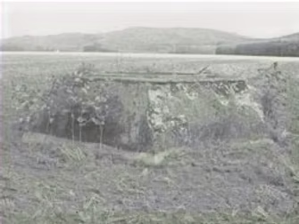
Po radarové stanici zůstaly v polích pouze dva podstavce a rozvalina hlavní budovy.
Postavec pro radiolokátor má tvar komolého šestistěnného jehlanu. Výška je 1,2 m. Vnitřní průměr 1,5 m. Na boku je čtyřhranný vchod, původně opatřen dvířky, který sloužil ke vstupu do spodní části podstavce, odkud vedly od radiolokátoru kabely. Otvory pro kabely jsou dosud zachovány v stěnách objektu. Jedná se o 5 trubkovitých výstupů o průměru 10 cm vedoucích šikmo dolů do betonové šachty. Kabely vedly pod zemí do budovy vyhodnocovačů. Na horní plošině podstavce jsou dobře patrné uřezané zbytky kovových tyčí o průměru 4 cm.
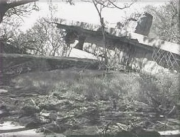
Poválečný snímek ukazuje výbuchem zničený radiolokátor WÜRZBURH RIESE, dosud stojící na svém betonovém podstavci. Dobře je vidět poškozená anténa, typický betonový podstavec a otočná kabina.
Trosky jiného objektu jsou vidět vpravo od cesty, která vede do “Jouřova” a “Pod Vrbičky” Je to zarostlá hromada betonových trosek, která zbyla po otočném radiolokátoru JAGDSCHLOSS. Jednalo o objekt s betonovým stropem, zdi byly betonové s cihlovými příčkami. Rozměry půdorysu byly asi 20 x 20 metrů. V dne 16. dubna 1945 byl objekt zničen trhavinou. Protože se jednalo o masivní železobetonové bloky, došlo jen k rozvalení a propadnutí stropu. Také další radary byly zničeny a ještě 18. dubna v den osvobození Ivančic) kolem 10. hodin byly objekty bombardovány sovětskými letadly.
Většina zařízení byla tedy zničena, pamětníků je velmi málo a další generace již o letišti a radarové stanici neví. V Okresním archivu v Rajhradě bohužel není dokumentace k letišti ani k odposlouchávací stanici, takže nezbývá spoléhat pouze na informace z obecních kronik a vzpomínek pamětníků. Jiří Široký
ZDROJE:
- Kolektiv autorů, Ivančice, dějiny města
- Pamětní kniha obce Budkovice – SOkA Rajhrad
- Pamětní kniha obce Němčice – SOkA Rajhrad
- Internet Budkovice – badatelna
Radar
Jedná se o statické zařízení určené pro měření vzdálenosti, výšky a polohy letadel. Při své činnosti se celý přistroj otáčel pro zaměření polohy a parabola se zvedala pro měření výšky. Jeho hlavní použití bylo při řízení stihání, ale i při určování polohy, příp. sloužil jako výstražný radar při přiblížení letadel. Tento radar býval i modifikován a používán pro pobřežní strážní službu.
Popis zařízeni: Jako podstavec sloužil betonový šestiúhelníkový blok, na kterém byla položena otočná deska a plošina. Ta nesla velikou kabinu, v níž bylo rádiové zařízení a pracovala obsluha. Na každé straně z boku bylo namontováno po jednom čepu, který nesl kovovou mřížovou parabolu. Zaměřování antény ve svislém směru zajišťoval ozubený segment (kolo). Parabola měla průměr 7,5 m a její jednotlivé díly byly vyrobeny z hliníkového plechu. Při zaměřování horizontálním se otáčela celá kabina i s reflektorem na čepu, který byl namontován v podstavci radaru. Většinou se na vrchol parabolické antény umisťovala anténa IFF (rozpoznávání letadel vlastních a cizích jako u předešlého typu), která byla sestavena ze dvou párů dipólů.

Radarové charakteristiky:
- Dosah: asi 70 km
- Výkon: 8 kW
- Opakovací impulsní četnost 1,875 imp./s.
- Šířka svazku s lalokovým přepínáním: 0 až 13°, 0 až 7,2° účinné
- Vlnová délka: 0,53 až 0,67 m
- Hmotnost: 12 tum
Na území Protektorátu Čechy a Morava byla za okupace vybudována síť pozemních radarových stanic letectva (FMG-St. – Funk Messgeräte Station). Tyto stanice byly pokračováním radarových sítí DETE I (dosah 150 km) a DETE II (dosah 200 km) budovaných již před válkou podél jižních a severních hranic Německa. Podle důležitosti byly a z taktických důvodů byly rozděleny do skupin I, II a III. Byly zřizovány, provozovány a obsluhovány příslušníky leteckého spojovacího vojska (Luftnachrichten Gruppe). Úkolem stanic bylo dodávat spolehlivé informace o leteckém provozu nad sledovaným územím. Kromě samotných radarů byly na stanicích i další budovy s provozním, technickým a hygienickým zázemím. Nejčastěji byly používány radiolokátory Freya, Wassermann (vodník), Würzburg Riese (Obr), Jagdschloss (Lovecký zámeček)a malé mobilní Würzburg C. Personální stav typické ústředny byl následující: velitel (vyšší důstojník), 5 velitelů čet a 1 nižší důstojník, 16 velitelů rojů, 12 vyhodnocovačů, 3 radiotelegrafisté, 7 stavěčů, 99 strážných a 14 mužů jiných odborností. Ke známým a poměrně dobře zdokumentovaným radarovým stanicím patří zejména stanice Koralle u Kolína. Kromě velkých stanic byly na vhodných místech (většinou lokalitách s dobrým výhledem) postaveny tzv. poplachové hlásky. Jejich obsluhy měly za úkol vizuální sledování vzdušného prostoru silnými dalekohledy. Vzhledem k rychle se měnící situaci na frontách byly stabilní radarové ústředny nahrazeny koncem války tzv. hlásnými vlaky, které nesly většinou radiolokátory Freya a Würzburg Riese .
Na poli u Budkovic je nejprve vlevo (při jízdě z Ivančic do Moravského Krumlova) dobře viditelný Objekt č. 1 – jeden z betonových podstavců pro radiolokátor FuMG 65 WÜRZBURG RIESE. Objekt 2 je poněkud dále v poli východním směrem. Podstavec pro radiolokátor má tvar komolého šestistěnného jehlanu. Výška je 1,2 m, vnitřní průměr 1,5m. Na boku je čtverhranný vchod, který byl původně opatřen dvířky (zachovaly se zbytky pantů).
Zřejmě sloužily k přístupu do spodní části podstavce, kudy vedly od radiolokátoru kabely. Otvory na kabely se dosud dochovaly ve stěnách objektu. Jedná se o 5 trubkovitých výstupů o průměru 10 cm vedoucích šikmo dolů do kabelové šachty, kterou už můžeme jen tušit ze zachovaných zbytků stěn. Dále zřejmě kabely vedly pod zemí do budovy vyhodnocovačů. Na horní ploše betonového podstavce jsou dobře patrné uřezané zbytky kovových tyčí o průměru 4 cm.